Errata and Amendments - Preliminary Maps
P.3842
On Preliminary Map P.3842, Precambrian Geology of Penhorwood Township, Northern Swayze Area, Abitibi Greenstone Belt, Northeastern Ontario, originally released December 2020, an incorrect reference was cited for the age of the Matchewan dike swarm in footnote “f” of the Legend. The correct reference should be Bleeker et al. (2015a), not Heaman (1988). In the list of Geochronology references, under “Sources of Information”, Heaman (1988) should not have been included. Additionally, the first Bleeker et al. reference should be “2015a”, and the second, “2015b”. In Table 1, for sample no.5, the reference should be Bleeker et al. (2015b), not “Bleeker et al. (2015)”. Additionally, the reference regarding corresponding and additional digital data related to the map has been updated to reflect the fact that Miscellaneous Release—Data 378, Geological, Geochemical and Geophysical Data Related to Penhorwood and Kenogaming Townships, Northern Swayze Area, Abitibi Greenstone Belt, Northeastern Ontario, was revised in 2021.
P.3841
On Preliminary Map P.3841, Precambrian Geology of Kenogaming Township, Northern Swayze Area, Abitibi Greenstone Belt, Northeastern Ontario, originally released November 2019 and updated December 2020, an incorrect reference was cited for the age of the Matchewan dike swarm in footnote “f” of the Legend. The correct reference should be Bleeker et al. (2015), not Heaman (1988). Additionally, Heaman (1988) should not have been included in the list of Geochronology references under “Sources of Information”. Additionally, the reference regarding corresponding and additional digital data related to the map has been updated to reflect the fact that Miscellaneous Release—Data 378, Geological, Geochemical and Geophysical Data Related to Penhorwood and Kenogaming Townships, Northern Swayze Area, Abitibi Greenstone Belt, Northeastern Ontario, was revised in 2021.
Preliminary Map P.3841, Precambrian Geology of Kenogaming Township, Northern Swayze Area, Abitibi Greenstone Belt, Northeastern Ontario (released December 2019), has been updated to correct a geochronology age associated with the Matachewan Dike Swarm (unit 28). It should be 2460 Ma. A new geochronology sample (18LV190) has been added to the map and Table 1. Additionally, the location map, and text in the legend footnotes and in “Sources of Information” have been updated to align with those in adjacent map P.3842, published December 2020, and maps P.3847 and P.3848, to be published in 2021. The grey colour of unit 7 (chemical metasedimentary rocks) was also darkened to align with that used on the abovementioned maps.
A new version of this map is available. If you purchased a copy of this map and wish to receive a replacement copy, please contact Publication Sales, and the new version will be shipped to you free of charge. Alternatively, the new version of Preliminary Map P.3841 is available for free downloading on GeologyOntario.
P.3838, P.3839 and P.3840
Preliminary Map P.3838, Quaternary Geology of the Cochrane Area, Northeastern Ontario, Map P.3839, Quaternary Geology of the Abitibi Area, Northeastern Ontario, and Map P.3840, Quaternary Geology of the Iroquois Falls Area, Northeastern Ontario (all released June 11, 2019), have been updated to include information to indicate these maps are associated with Preliminary Map P.3836, Quaternary Geology of the Kapuskasing Area, Northeastern Ontario, and Map P.3837, Quaternary Geology of the Smooth Rock Falls Area, Northeastern Ontario (both released May 29, 2020). Maps P.3838, P.3839 and P.3840 have a new appearance, but the technical information provided in these maps has not changed. The updates are the following: 1) footnotes indicating that all 5 maps have a common legend were added to i) “Legend” and ii) “Symbols”; 2) Figure 1, the outline of the Cochrane extent of lidar digital terrain model data, was modified to include the lidar extents for all 5 map areas; and 3) the location map was modified to include the locations of all 5 maps.
If you have purchased a copy of P.3838, P.3839 and/or P.3840 and wish to receive replacement copies, please contact Publication Sales and the new version will be sent to you free of charge. Alternatively, the new versions of Preliminary Map P.3838, Preliminary Map P.3839 and Preliminary Map P.3840 are available for downloading free of charge on GeologyOntario.
P.3829
Preliminary Map P.3829, Precambrian Geology of the Wabassi River Area, Fort Hope–Miminiska Greenstone Belt, Northwestern Ontario (released June 30, 2021), was published with an error in the marginal notes. In the first paragraph under “Mineral Potential”, a value of 29.8 g/t was stated for Au, where it should have been for Ag. The text should say: “The National Instrument 43-101–compliant Inferred Resources for the deposit are 1.04 million tonnes grading 1.10% Cu, 4.21% Zn, 29.8 g/t Ag…..” (not 29.8 g/t Au).
This error has been corrected and a replacement map is available. If you purchased a copy of this map, please contact Publication Sales and a replacement map will be sent to you free of charge. Alternatively, and for clients who downloaded the map from GeologyOntario, the corrected version of Preliminary Map P.3829 is available to download.
P.3823
Preliminary Map P.3823, Precambrian Geology of Drury Township, Southwest Sudbury Structure (released December 19, 2018), was published with an error in the geological legend. The description for unit 4 should read “Mafic Intrusive Rocks (likely correlative to the Matachewan dike swarm) (2480 to 2446 Ma)i ”, where the footnote “i” indicates that the age range is based on rock unit ages from Heaman (1997) and Bleeker et al. (2012). The descriptions of subunits 4a, 4b and 4c are correct.
This error has been corrected and a replacement map is available. If you purchased a copy of this map, please contact Publication Sales and a replacement map will be sent to you free of charge. Alternatively, and for clients who downloaded the map from GeologyOntario, the corrected version of Preliminary Map P.3823 is available to download.
P.3813
Preliminary Map P.3813, Precambrian Geology of Adrian Township, Shebandowan Greenstone Belt, Wawa–Abitibi Terrane (released April 4, 2017), has been updated to include geochronology data not available at the time of the original release. Information on the 3 previously pending ages has been added to the map face and also in Table 2. Please note, information regarding these ages also resulted in changes to the “Legend” and the “Marginal Notes” accompanying the map.
A new version of this map is available. If you have purchased a copy of this map and wish to receive a replacement copy, please return the map to Publication Sales and new plot of this map will be sent to you free of charge. Alternatively, the new version is available for downloading at Preliminary Map P.3813.
P.3812
Preliminary Map P.3812, Precambrian Geology of Tuuri and Walsh Townships, Northern Ontario (released April 4, 2017), has been updated to include geochronology data not available at the time of the original release. Information on the 8 new ages has been added to the map face and also in Table 1; additionally, 2 new references have been added to the "Sources of Information".
A new version of this map is available. If you have purchased a copy of this map and wish to receive a replacement copy, please return the map to Publication Sales and a new plot of this map will be sent to you free of charge. Alternatively, the new version of Preliminary Map P.3812 is available for downloading free of charge on GeologyOntario.
P.3786
Preliminary Map P.3786, Precambrian Geology of Thorneloe and Price Townships (released on April 15, 2014), was published with an incorrect longitudinal measurement plotted at 1 corner of the map sheet: the northeastern extent is 48°21′50″N, 81°20′07″W (not 48°21′50″N, 84°20′07″W); all other measurements are correct.
This error has been corrected and a replacement map is available. If you purchased a copy of this map and wish to receive a replacement copy, please contact Publication Sales and a correct plot of this map will be sent to you free of charge. Alternatively, and for clients who downloaded the map from GeologyOntario, the corrected version is available for downloading at: Preliminary Map P3786.
P.3770
Preliminary Map P.3770, Quaternary Geology, Burntbush Area, Northeastern Ontario (released on April 16, 2013), was published with errors in the geological legend. The box showing the colour for Unit 8 was missing; additionally, the colours for Unit 7 and Unit 6 were matched to the wrong description in the legend. The remainder of the legend is correct.
These errors have been fixed and a replacement map is now available for those clients who purchased Preliminary Map P.3770 with the incorrect legend. Please contact Publication Sales and a replacement map will be sent to you free of charge. Alternatively, you may download the corrected version of Preliminary Map P.3770 files from our GeologyOntario Web site.
P.3710
Preliminary Map P.3710, Surficial Geology of the Lansdowne House Area Southeast, Northern Ontario (released June 4, 2013), was released with a slight registration problem north of Attawapiskat River. This error has been corrected and a replacement map is now available for those clients who purchased Preliminary Map P.3710. Please contact Publication Sales and a replacement map will be sent to you free of charge. Alternatively, you may download the corrected version of Preliminary Map P.3710 files from our GeologyOntario Web site. (notice issued: August 9, 2016)
P.3761
Preliminary Map P.3761, Precambrian Geology of the Split Lake Area, Northwestern Ontario (released April 5, 2011), has been updated to include geochronology data not available at the time of the original release. Detailed information on the 2 new ages and their locations have been added to the map, but is also provided in the table below. Location information is provided as Universal Transverse Mercator (UTM) co-ordinates using North American Datum 1983 (NAD83) in Zone 15N.
A new version of this map is available. If you have purchased a copy of this map and wish to receive a replacement copy, please return the map to Publication Sales and new plot of this map will be sent to you free of charge. Alternatively, and for clients who downloaded the map from GeologyOntario, the new version is available for downloading at: Preliminary Map P3761.
P.3611
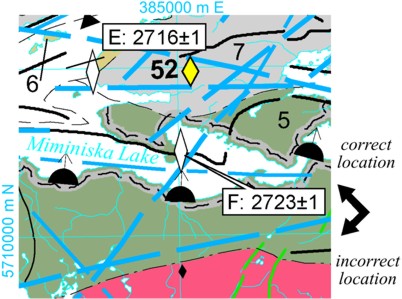
On Preliminary Map P.3611, Geological Compilation of the Miminiska–Fort Hope Area, Eastern Uchi Domain (released April 14, 2009), a geochronological sample was mislocated. As shown in the figure below, sample “F”, on the map and listed in Table 1, is located at UTM co-ordinates 385049E 5712532N (shown below by the large white diamond labelled “F”) not 385079E 5708923N (as shown below by the small black diamond). The UTM co-ordinates are provided using NAD83, Zone 16.
P.3607
On Preliminary Map P.3607, Precambrian Geology of the Winisk Lake Area, Northwestern Ontario, released April 7, 2009, the geochronological age reported for sample site 4 in the northeast part of the map face should read “<2719 ± 2 Ma” not “2919 ± 2 Ma”. The age is correctly reported, however, in Table 2.
P.3598-Revised
On Preliminary Map P.3598-Revised, released August 6, 2008, a dike in the southeast corner of the map was inadvertently mislabelled. The dike, which trends northwest and intersects the southern border of the map between longitudes 82°W and 83°W is shown as gold in colour and labelled 33a. It should have been green and labelled 26b. This error has been corrected. If you have purchased a copy of this map and wish to receive a replacement copy, please return the map to Publication Sales and a correct plot of this map will be sent to you free of charge. Alternatively, and for clients who downloaded the map from GeologyOntario, a correct version is available for downloading at:P3598-REV
The error in Preliminary Map P.3598-Revised also affects Miscellaneous Release—Data–233, which was released in conjunction with Preliminary Maps P.3598-Revised, P.3597-Revised and P.3599. The digital data on this publication contained portable document format (.pdf) files of each map as well as a seamless (merged) PDF file of all 3 maps. The PDF files of Preliminary Map P.3598-Revised (p3598-rev.pdf) and of the seamless version (Seamless-p3597-99.pdf) have been corrected. Clients who purchased this MRD and wish to receive a replacement copy may return their DVDs to Publication Sales and a replacement copy will be sent to you free of charge. Alternatively, and for those clients who downloaded the MRD from GeologyOntario, a correct version is available for downloading at: MRD233
To download only the 2 corrected files (p3598-rev.pdf and Seamless-p3597-99.pdf), please go to the following sites:
p3597-rev.pdf
Seamless-p3597-99.pdf
P.3597 and P.3598
On Preliminary Maps P.3597 and P.3598, released October 9, 2007, there is an error in Figure 1. A small, light-blue-coloured polygon was inadvertently placed just south of an important mafic intrusion, making the intrusion look much larger than it is.
P.3590
On Preliminary Map P.3590, Precambrian Geology of the McInnes Lake Greenstone Belt, Northwestern Ontario-South Sheet (released December 11, 007), sold separately, with Open File Report 6210 and on Miscellaneous Release-Data 222, geologic subunit 6c was omitted from the "Legend". Unit 6c is a pyroxenite; the only outcrop is located at UTM co-ordinates 453169E 5780872N (NAD83, Zone 15). This error has been corrected. If you have purchased a copy of any of these publications and would like a replacement, please return the publication(s) to Publication Sales, and a replacement copy will be sent to you free of charge.
P.3541 and P.3542
On Preliminary Map P.3541, Precambrian Geology of Shaw Township and P.3542, Precambrian Geology, Eldorado and Adams Townships (released April 14, 2004) the colours for geologic units 1, 4, 5 and 7 were plotted incorrectly. In addition, an error was noted in a geologic contact in the north-central portion of map P.3541. These errors have been corrected. If you have purchased a copy of either of these maps and would like a replacement, please contact Publication Sales, and a corrected copy will be sent to you free of charge.
P.3534
Preliminary Map P.3534, Precambrian Geology of Otto and Eby Townships, was released (March 8, 2004) plotted at a scale of 1:19 000 rather than the intended 1:20 000. If you purchased a copy of this map, please contact Publication Sales and a correct plot of this map will be sent to you free of charge.
P.3407, P.3408, P.3411 and P.3413
The following maps by S.B. Lumbers and V.M. Vertolli, released January 10, 2000, have a symbol in the Symbols list mislabelled:
P.3407, Precambrian Geology, Orillia Area;
P.3408, Precambrian Geology, Elmvale Area;
P.3411, Precambrian Geology, Bracebridge Area; and
P.3413, Precambrian Geology, Huntsville Area.
The symbol labelled "Bedding; sedimentary, volcanic or other (horizontal)" should have been labelled "Compositional layering and/or parallel tectonic foliation (horizontal)".
P.3395
On Map P.3395, titled Geological Compilation, Beatty and Munro Townships (July 12, 1999), 16 diamond-drill holes were mislocated in the vicinity of the Potter Mine from their actual locations 2 km north, in the vicinity of the Potter Doal Mine, north-central Munro Township. If you have purchased a copy of this map, please return it to Publication Sales and a correct plot of this map will be sent to you free of charge.
P.3390
Preliminary Map P.3390 titled, Precambrian Geology Willet-Gledhill Lakes Area, Onaman-Tashota Greenstone Belt, was released with the wrong NTS reference. The correct NTS reference is 42 L/3, 4, 5, 6.
P.3388
On Map P.3388, titled Precambrian Geology, Hwy 101 West (March 15, 1999), 2 areas of rock unit 1 (ultramafic and mafic metavolcanic rocks) in the extreme eastern part of the map, at UTM 5373000N, were coloured incorrectly. If you have purchased a copy of this map, please return it to Publication Sales and a correct plot of this map will be sent to you free of charge.
P.3363
A "Properties" list belonging to another map was inadvertently included in the marginal material of Map P.3363, entitled Precambrian Geology, Hurdman Township Zinc Occurrence. Map P.3363 should not have a "Properties" list. (September 9, 1996)
P.3357
Map P.3357, entitled Preliminary Observations on Mineralization and Alteration in Elmhirst and Rickaby Townships, sold separately and with Open File Report 5936, was inadvertently published at an incorrect scale. Clients who purchased a copy of either of these publications may return their map to the Publication Sales outlet, and it will be replaced by a map at the correct scale at no charge. (March 11, 1996)
P.3349
Some copies of Map P.3349, entitled Geology of the Atikokan Area, may have been plotted with incorrect longitudinal measurements. The longitudinal measurement for the map area's west boundary should be 92˚ (not 94˚), and for the east boundary, 91˚30' (not 93˚45'). (December 11, 1995)
P.3344
Map P.3344, entitled Mineral Resource Assessment Map of the Grassy River Area, was released with line types plotted incorrectly. If you purchased a copy of Map P.3344 or a copy of OFR 5930, which this map accompanies, prior to February 1, 1996, please return your map to Publication Sales, and a correct plot of this map will be sent to you free of charge. (December 11, 1995)
P.3339
Map P.3339, entitled Paleozoic Geology of the Penetanguishene-Elmvale Area, Southern Ontario, is a 1:50 000 scale map but was inadvertently published with a 1:20 000 scale bar. (August 31, 1995)
P.3320
Map P.3320, entitled Mineral Occurrences and Precambrian Geology, Larder Lake Area, a 1:50 000 scale map, was inadvertantly published with a 1:25 000 scale bar.
P.3303
Preliminary Map P. 3303, entitled Precambrian Geology, Michipicoten Greenstone Belt, Central Portion, announced in the December 1994 Publications Release Notice, was released without dip values for the structural symbols. If you have purchased a copy of Preliminary Map P.3303 and it is missing this information, please return your map to Publication Sales and a correct version will be sent to you free of charge. (December 5, 1994)
P.3302
Map P.3302, entitled Geology of Marko's Pegmatite, Separation Rapids Pegmatite Group, Separation Lake Greenstone Belt (December 11, 1995), was released with one of the outcrop units miscoded. The north half of the large western outcrop should be labelled as follows:
P.3269
Two known gold-bearing zones, delineated by diamond drilling and meeting the OGS mineral occurrence requirements, were left off Preliminary Map P.3269, Precambrian Geology, Opikeigen Lake Area. The occurrences are known as the OL12 and OL29 zones located southeast of Opikeigen Lake. The location for diamond-drill hole OL-87-12 is Zone 16, NAD83, 5719050N; 427600E. The location for diamond-drill hole OL-87-29 is Zone 16, NAD83, 5719150N; 427000E.
P.3187
The name of the author of Map P.3187, Bedrock Geology of the Regional Municipality of Sudbury, was spelled incorrectly in the November 1998 Publications Release Notice. The correct spelling of the author's name is D. Rousell. (November 9, 1998)
P.2847 and P.2846
Preliminary Maps P.2846, Precambrian Geology, Jocko River Area, and P.2847, Precambrian Geology, Songris Area (on June 5 release notice; released on June 13, 2006), were plotted with incorrect latitudinal and/or longitudinal measurements. On the location map for each map, the correct latitude should be 46˚30′N (not 49˚30′N). Map P.2846 also had incorrect latitudinal and longitudinal measurements plotted at the corners of the map sheet: the northwestern extent is 46˚52′14″N, 79˚25′31″W (not 45˚52′14″N, 79˚25′31″W); the southwestern extent is 46˚34′26″N, 79˚26′02″W (not 46˚34′00″N, 79˚25′31″W); the southeastern extent is 46˚34′01″N, 79˚00′00″W (not 46˚34′00″N, 78˚58′39″W); the northeastern extent of 46˚51′52″N, 79˚01′55″W is correct, as are all other measurements. These errors have been corrected. If you have purchased a copy of either of these maps and would like a replacement, please contact Publication Sales, and a corrected copy will be sent to you free of charge.